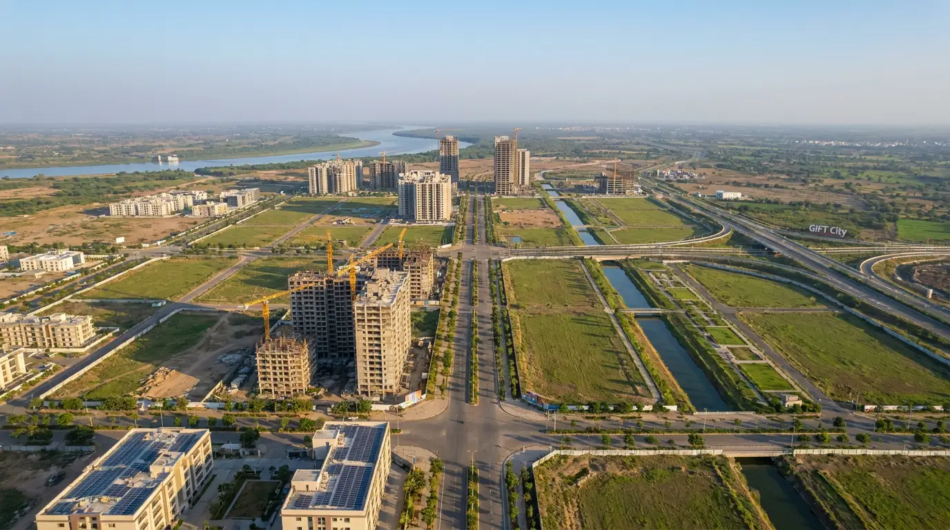
The Ahmedabad-Dholera Expressway is a roughly 109 km access-controlled corridor linking Ahmedabad to the Dholera Special Investment Region. It is reported to have become operational in 2026 and cuts the journey to about 40 to 45 minutes. This guide covers its route, status, travel time and toll, using only verifiable facts and flagging anything still reported or planned.
- About 109 km, four lanes, access-controlled, expandable to eight
- Reported operational in 2026; confirm live status before travel
- Journey reported at about 40 to 45 minutes; NHAI toll via FASTag
What the Ahmedabad-Dholera Expressway is
If one road defines Dholera's arrival on the map, it is this one. The Ahmedabad-Dholera Expressway is a modern, access-controlled highway built to connect Gujarat's largest city directly to the Dholera Special Investment Region (SIR), India's flagship greenfield smart city under the Delhi-Mumbai Industrial Corridor. It is reported to be about 109 km long, built initially as a four-lane corridor and designed to be widened to eight lanes as traffic grows (Wikipedia).
The project is built by the National Highways Authority of India (NHAI). It has been described as part of the wider highway programme feeding the Dholera region, with a reported construction cost of about Rs 3,196 crore excluding land (Blackridge Research). For anyone weighing Dholera as a place to live, work or invest, this expressway is the single biggest reason the region no longer feels remote.
Status in 2026
The expressway is reported to have become operational in 2026. Public and government sources report an inauguration on 31 March 2026, with sections opened to traffic during a phased and trial-run period before that (Press Information Bureau). In the months leading up to full opening, progress was reported at well over 90 percent complete, with the remaining stretches finishing rapidly (Knocksense).
Because opening dates for large infrastructure can shift and phases can open separately, treat the 2026 operational status as reported and confirm the live position before you plan a trip. Where a specific stretch or ramp is still being finished, official NHAI updates are the source of truth.

Route and design
The corridor begins at the Sardar Patel Ring Road near Sarkhej, on the south-western side of Ahmedabad, and heads south toward the coast. It passes through the Dholera SIR and continues to Adhelai village in Bhavnagar district, tying the smart city into the Ahmedabad-Bhavnagar movement axis (Wikipedia). Reported waypoints along the way include areas such as Sindhrej and Vejalka before the road reaches the Dholera region (Anirudh Singh Dholera).
The defining feature is that it is access-controlled. Unlike an ordinary state highway where vehicles join and leave anywhere, this expressway has designed entry and exit points only. That is what allows consistent high speeds and safer, more predictable travel. The proposed Dholera International Airport, planned near Navagam, sits close to this corridor, which is part of why the road, the airport and the city are usually discussed together.
Travel time: then and now
The headline benefit is time. On older conventional roads, the run between Ahmedabad and Dholera SIR took roughly two to two and a half hours depending on route and traffic. On the expressway, the journey is reported to fall to around 40 to 45 minutes (India.com). That is the difference between Dholera feeling like a distant industrial site and feeling like a genuine extension of the Ahmedabad metropolitan region.
For a fuller comparison of routes and drive times, see our companion guide on the Ahmedabad to Dholera distance.
Toll on the expressway
This is a tolled, access-controlled expressway, so a user fee applies. Toll is collected by NHAI through the FASTag electronic system rather than cash lanes wherever possible. Reports place a toll plaza near Bhadbhid village in Bhavnagar district, covering a tollable section of roughly 30 km toward the Adhelai end (Dholera Guru).
Specific per-vehicle toll amounts are set by government notification and are revised periodically, typically in line with an inflation index. Because published rates can change, we do not quote a fixed figure here; verify the current rate through NHAI or an official toll notification before travelling. What is reliable is the principle: expect a FASTag-based toll for using the corridor.
Why it matters for Dholera
Connectivity is what turns a master plan into a working city. With the expressway, Dholera gains fast, reliable road access to Ahmedabad's airport, universities, hospitals and labour market, which matters for both the industrial anchors setting up in the region and the families who might live there. It also complements the other connectivity pieces being planned around Dholera, including the proposed metro and rail links covered in our Dholera metro and MRTS guide.
For buyers and investors, better connectivity is the classic driver of land demand, but it is not a guarantee of any specific return. If you are evaluating plots, pair this connectivity picture with the ground realities in our Dholera master plan and TP schemes guide, and always verify a project's Gujarat RERA registration, clear title and non-agricultural status before committing. You can also compare builders neutrally in our top Dholera developers guide.
Quick reference
Length: about 109 km · Lanes: four, expandable to eight · Type: access-controlled expressway · From/to: Sarkhej (Ahmedabad) to Adhelai (Bhavnagar district) via Dholera SIR · Status: reported operational 2026 · Travel time: reported about 40 to 45 minutes · Toll: NHAI FASTag, rate by notification.
Try the Dholera tools →Frequently asked questions
How long is the Ahmedabad-Dholera Expressway?
It is reported to be about 109 km, built as a four-lane access-controlled corridor designed to expand to eight lanes, running from Sarkhej in Ahmedabad to Adhelai in Bhavnagar district via Dholera SIR.
Is the expressway open in 2026?
It is reported to have become operational in 2026, with an inauguration reported on 31 March 2026 and some stretches opened earlier during phased operation. Confirm the live status before planning travel.
How much time does it save?
Travel between Ahmedabad and Dholera SIR is reported to drop to roughly 40 to 45 minutes, against about 2 to 2.5 hours on older conventional roads.
Is there a toll?
Yes. It is a tolled access-controlled expressway with NHAI collecting toll via FASTag, and a toll plaza reported near Bhadbhid village in Bhavnagar district. Per-vehicle rates are set by notification and change over time, so check the current rate before you travel.
Who built it?
It is built by the National Highways Authority of India (NHAI), with a reported construction cost of about Rs 3,196 crore excluding land.